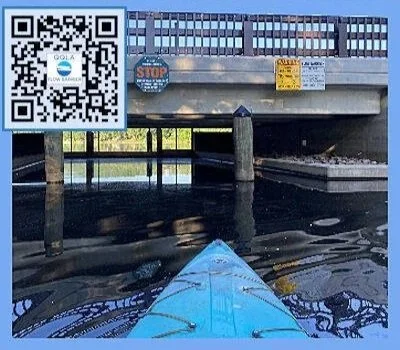
Standing at the boat ramp on Lake Quaboag “North Pond”, it is connected to Lake Quacumquasit “South Pond,” at a bridge 1.6 miles South of this ramp. Attached to the bridge is a FLOW BARRIER.
Flow Barrier
Why a “Flow Barrier”
Authored by Randy Weiss, Don Taft and Doug Vizard
2026 Update
Lake Quaboag (North Pond) and Lake Quacumquasit (South Pond) are connected at the bridge on Lake Rd / S. Pond Rd near the South Pond Boat Ramp. Water normally flows under the bridge FROM South Pond INTO North Pond. Attached to this bridge is the “FLOW BARRIER” that was installed in 1991. This barrier is manually raised or lowered as needed to help prevent ‘Backflow’ into South Pond.
It is a quirk of the shapes and sizes of these ponds, and their associated watersheds, that certain rain events cause the ‘lower’ North Pond to have its level rise higher than the level in the normally ‘upstream’ South Pond. This is due to the radical difference in the size of each watershed: South Pond’s watershed is about 2 (two) square miles, tiny in comparison to North Pond’s watershed of over 76 (seventy-six) square miles! The result of a heavy rain is for South Pond’s level to ‘crest’ quickly, 6-12 hours after a rainfall; North Pond’s level takes between 45 - 55 hours to peak, at which time backflow into South Pond often results.
Backflow would not be much of a concern if not for the water contaminants found in North (but not in South) Pond, namely phosphorus, other chemicals, and invasive weed species. The sources of these contaminants is a different discussion. Data developed between 1985 and 1990, plus more recent data from a Mass DEP study supports the decision to install the flow barrier.
An additional cause for concern relates to the ‘retention time’ of the water in each pond. South Pond is 225 acres, its average depth is just over 30 feet. North Pond is twice as large at 540 acres, but only 1/5th as deep (6.6 feet on average), so it actually holds considerably less water volume. The retention time of the water in North Pond is only 12 days on average. Conversely South Pond’s retention time is 1.46 YEARS – 40 times longer! Conclusion: prevent backflow conditions in the first place, hence the flow barrier.
QQLA volunteer members participate with the town of E. Brookfield in both monitoring flow conditions and in the operation of the barrier. The physical (manual) raising and lowering of the barrier is accomplished solely by QQLA volunteers.
An undesirable side-effect of the lowered barrier is the impediment to watercraft passing under the bridge. Small craft can be portaged over the road easily as there is a boat ramp on each side of the bridge. The position of the barrier can be determined visually if one is at the barrier. If not, Click on the BUTTON below.
How the “Flow Barrier” Works
Authored by Randy Weiss, Don Taft and Doug Vizard
Sept 2016 and 2026 Update
Lake Quaboag (North Pond) and Lake Quacumquasit (South Pond) have a ‘Flow Barrier’ that is used to prevent ‘backflow’ from North Pond to South Pond during certain rain events.
This section describes HOW IT WORKS.
Step #1: Monitor the Lake Levels – One can look down from the bridge over the ‘canal’ between the two lakes to see which way the water is flowing when the barrier is OPEN. If the flow is INTO South Pond then the barrier needs to be lowered. There is also a gauge on each side -- QQLA volunteers use these gauges to make a measure and record lake levels. Also these gauges are required to determine when the backflow condition has ended necessitating raising the barrier. The procedure for raising or lowering the barrier is identical.
It is also possible to ‘predict’ backflow conditions by closely monitoring the two USGS river gauges that upload data every 15 minutes to the web (Waterwatch.usgs.gov … select ‘Current’ … Select state: MA … browse map to find the Quaboag River & 7-Mile River).
Step #2: Gain permission -- QQLA volunteers (sometimes a single person) meet at the barrier to verify the backflow condition. Each time before lowering the barrier they must gain permission from the town of East Brookfield since the barrier is ‘owned’ by the town. A phone call is made to a selectman, and permission granted in almost every case. It is hoped this step will be made unnecessary in the future.
Step #3: Sound the Horn – In order to alert any boaters who have used (or intend to use) the canal that the passage will be CLOSED to boat traffic, a loud portable boat horn is sounded. Quiet hours are respected..
Step #4: Manipulation of the barrier – The mechanism that raises/lowers the barrier has a ‘hand crank’ that is kept in a lock box. However, the effort involved in manual operation was found to be excessive. Subsequently an electric drill was specifically adapted to turn the gears. This machine requires 110v power, so the QQLA has obtained a small portable generator. Together these two machines can be operated by a single volunteer, and can raise / lower the barrier in about 10 - 15 minutes.
Step #5: At one time in the past a FLAG at North Pond’s Boat Ramp was used to alert boaters of the ‘current’ status of the barrier. This has been replaced by a dedicated website [ IsTheBarrierOpen.org ] which is updated by a QQLA volunteer very shortly after the barrier is raised or lowered. Click the link below.
“Flow Barrier” Operational Authority
MA DEP Order of Conditions (OOC) File Number 149-0113 and License Plan # 1991 (prepared by Harry R. Jones P.E.) approved by the Department of Environmental Quality Engineering (DEQE), prepared and submitted on August 31, 1989. These referenced MA DEP and DEQE documents, authorizes and establishes controls for the operation of the South Pond Flow Barrier, for the purpose of the control of Daily Load limits of Phosphorus in Quaboag and Quacumquasit Ponds, a structure was that was approved and installed under a MA DEP 319 grant for water quality control and management. The OOC was prepared and submitted by QQLA acting as the agent for the Town of East Brookfield and the East Brookfield Conservation Commission. These OOC are issued by the State of Massachusetts and are to be strictly followed for the operation of the Flow Barrier.
These OOC authorize QQLA to operate the Flow Barrier as an agent for the Town of East Brookfield under the management of the East Brookfield Board of Selectmen, the Conservation Commission and the Town of East Brookfield Highway Department.
These OOC are issued to ensure the operation of the Flow Barrier is managed in a way as to protect the waters of Quaboag and Quacumquasit Ponds, during backflow conditions. The operation of the Flow Barrier must follow these operational requirements, the Flow Barrier shall not be operated outside of these conditions without the express written authorization granted by the East Brookfield Board of Selectmen, the East Brookfield Conservation Commission and the East Brookfield Highway Departments.